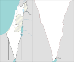
Paran, Israel
Paran
פארן | |
|---|---|
 | |
| Coordinates: 30°21′47″N 35°9′13″E / 30.36306°N 35.15361°E | |
| Country | |
| District | Southern |
| Council | Central Arava |
| Affiliation | Moshavim Movement |
| Founded | 1971 |
| Founded by | Nahal |
| Population (2022)[1] | 537 |

Paran (Hebrew: פארן) is a moshav in southern Israel. Located in the Arabah valley around 100 km north of Eilat, it falls under the jurisdiction of Central Arava Regional Council. In 2022 it had a population of 537.[1]
History
[edit]The moshav is named after a passage in the Book of Genesis (21:20–21):[2] "And God was with the lad, and he grew, and dwelt in the wilderness, and became an archer. And he dwelt in the wilderness of Paran. And his mother took him a wife out of the land of Egypt."
Economy
[edit]Each of the family farm units covers 50 dunams (50,000 m2). The main crops are high quality peppers and flowers for export. In addition, 14 of the families run a cowshed of 40-45 dairy cows each. Among the smaller farm branches are a date palm orchard and turkey production.
Some families supplement their income with other activities such as a horseback riding school, a nursery for vegetable and flower seedlings, cottage industries producing arts and crafts articles, and jeep tours.[original research?]
In 2008 new rules in Israel made solar power profitable.[clarification needed] Some families started to produce electricity (commercially) from 50 kWp photovoltaic power plants (per family), using the area's high daily solar radiation and dry weather.[citation needed]
Services
[edit]The moshav offers its members a variety of community services including a kindergarten, nursery, members' club, youth club, swimming pool, garage, fitness, public gardens and a well-stocked library, minimarket.
References
[edit]- ^ a b "Regional Statistics". Israel Central Bureau of Statistics. Retrieved 21 March 2024.
- ^ Bitan, Hanna: 1948-1998: Fifty Years of 'Hityashvut': Atlas of Names of Settlements in Israel, Jerusalem 1999, Carta, p.56, ISBN 965-220-423-4 (in Hebrew)


